London Borough of Haringey
| London Borough of Haringey | |||
|---|---|---|---|
| — London borough — | |||
|
|||
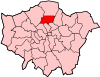
| Haringey shown within Greater London | |||
| Sovereign state | United Kingdom | ||
| Constituent country | England | ||
| Region | London | ||
| Ceremonial county | Greater London | ||
| Status | London borough | ||
| Admin HQ | Wood Green | ||
| Incorporated | 1 April 1965 | ||
| Government | |||
| - Type | London borough council | ||
| - Body | Haringey London Borough Council | ||
| - Leadership | Leader (Cllr Claire Kober) & Cabinet (Labour) | ||
| - Mayor | Cllr Bernice Vanier | ||
| - MPs | Lynne Featherstone David Lammy |
||
| - London Assembly | Joanne McCartney AM for Enfield and Haringey | ||
| - EU Parliament | London | ||
| Area | |||
| - Total | 11.4 sq mi (29.59 km2) | ||
| Area rank | 311th (of 326) | ||
| Population (2008 est.) | |||
| - Total | 226,200 | ||
| - Rank | 60th (of 326) | ||
| - Density | 19,799.1/sq mi (7,644.5/km2) | ||
| - Ethnicity[1] | 47.6% White British 3.6% White Irish 14.1% Other White 1.4% White & Black Caribbean 0.8% White & Black African 1.2% White & Asian 1.3% Other Mixed 3.0% Indian 1.3% Pakistani 1.6% Bangladeshi 1.7% Other Asian 8.3% Black Caribbean 9.1% Black African 1.3% Other Black 1.5% Chinese 2.2% Other |
||
| Time zone | GMT (UTC0) | ||
| - Summer (DST) | BST (UTC+1) | ||
| Postcodes | {{{postcode_areas}}} | ||
| Police force | Metropolitan Police | ||
| Website | [LB Haringey LB Haringey] | ||
See also: Harringay for the neighbourhood in the London Borough of Haringey
The London Borough of Haringey (pronounced /ˈhærɪŋɡeɪ/ (![]() listen)[2]) is a London borough, in North London, classified by some definitions as part of Inner London, and by others as part of Outer London. It was created in 1965 by the amalgamation of three former boroughs. It shares borders with six other London boroughs. Clockwise from the north, they are: Enfield, Waltham Forest, Hackney, Islington, Camden, and Barnet.
listen)[2]) is a London borough, in North London, classified by some definitions as part of Inner London, and by others as part of Outer London. It was created in 1965 by the amalgamation of three former boroughs. It shares borders with six other London boroughs. Clockwise from the north, they are: Enfield, Waltham Forest, Hackney, Islington, Camden, and Barnet.
Haringey covers an area of more than 11 square miles (28.5 km2).[3] Some of the more familiar local landmarks include Alexandra Palace, Bruce Castle, Highpoint I and II, and Tottenham Hotspur Football Club.
The borough is very ethnically diverse. It has extreme contrasts:[4] areas in the west, such as Highgate, Muswell Hill and Crouch End are among the most prosperous in the country; in the east of the borough, some wards are classified as being among the most deprived 10% in the country.[5]
Haringey is also a borough of contrasts geographically. From the wooded high ground around Highgate and Muswell Hill, at 426.5 feet (130.0 m), the land falls sharply away to the flat, open low lying land beside the River Lea in the east. The borough includes large areas of green space, which make up more than 25% of its total area.[5]
In recent years, Haringey Council has become the subject of nationwide criticism over its handling of the welfare of young children in connection with the murder of Victoria Climbie and the death of Baby P.[4]
In March 2009, Haringey Council's performance was placed by the Audit Commission in the bottom four of the country and the worst in London.[6]
In December 2009, Haringey's performance was placed by Ofsted in the bottom nine in the country for children's services.[7]
Contents |
History
In the Ice Age, Haringey was at the edge of a huge glacial mass that reached as far south as Muswell Hill.[8] There is evidence of both Stone Age and Bronze Age activity.[9]
Prior to the Romans' arrival, Haringey was part of a large area covering Essex and Middlesex which was home to a celtic tribe called Trinobantes.
The Romans' presence is evidenced chiefly by the roads they built through the area. Tottenham High Road was part of the main Roman thoroughfare of Ermine Street. There have also been Roman finds in the borough which suggests possible Roman settlement.
In the 5th and 6th centuries the Saxon invasions brought Haering, the chieftain whose name still lives on today in local placenames.
At the time of Domesday, the western part of modern Haringey was within the Manor of Harengheie and part of the Bishop of London's principal Manor of Stepney.[8] The eastern part was within the Manor of Tottenham held by Waltheof II, Earl of Northumbria, the last of the great Anglo-Saxon Earls.[10]
Haringey remained a rural area until the 18th century when large country houses close to London became increasingly common. The coming of the railways from the mid-nineteenth century onwards led to rapid urbanisation. So that by the turn of the century much of Haringey had been transformed from a rural to an urbanised environment.
The borough in its modern form was founded in 1965, from the former Municipal Borough of Hornsey, the Municipal Borough of Wood Green and the Municipal Borough of Tottenham which had all previously been part of Middlesex. The new borough became part of the new Greater London Council. However, some legacy of the historic municipal divisions survives to the present day, with the relative prosperity of the different parts of the borough still split broadly along the old boundary lines.
- See also: Category: History of Haringey.
Etymology
The names Haringey, Harringay[11] and Hornsey in use today are all different variations of the same Old English - Haeringes-hege. Haering was a Saxon chief who lived probably in the area around Hornsey. Haering's Hege, meant Haering's enclosure and evolved into Haringey, Harringay and Hornsey.
- See also: Etymology Section: Harringay Town's History
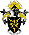
The Haringey coat of arms and logo
The official explanation of the coat of arms is given as:
| “ | The contrasting colours of black (sable) and gold (Or) symbolise stability - the element earth is traditionally represented in black - and enterprise. The half cogwheel in front of the rising sun represents industry and a bright future - the rising sun symbolises the new borough itself. The radiating golden rays symbolise action reaching out to the boundaries of the borough, those that revolve around the centre of the shield symbolise movement. They also allude to the first television transmission from Alexandra Palace, one of the landmarks in the borough of Haringey. The Heraldic decoration includes a mantling or cloth formerly worn on the back of the helmet to keep the sun off the wearer. The motto is Progress with Humanity.[12] | ” |
The modern logo is fashioned on the coat of arms.
Geography
Haringey is a borough of contrasts geographically. From the wooded high ground around Highgate and Muswell Hill, at 426.5 feet (130.0 m), the land falls sharply away to the flat, open low lying land beside the River Lea in the east. The borough includes large areas of green space, which make up more than 25% of its total area.[5]
Haringey shares borders with six other London boroughs. Clockwise from the north, they are: Enfield, Waltham Forest, Hackney, Islington, Camden, and Barnet. It covers an area of more than 11 square miles (28.5 km2).[3] Some of the more familiar local landmarks include Alexandra Palace, Bruce Castle and Tottenham Hotspur Football Club.
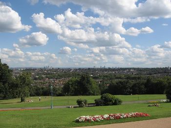
Haringey has 600 acres (2.4 km2) of parks, recreation grounds and open spaces[13] which make up more than 25% of its total area.[5] They include both smaller local areas and large green areas which provide an amenity for Londoners beyond the borough's boundaries. Local Nature Reserves and a number of conservation areas can also be found in the borough. The borough is also home to five distinct ancient woods. These are Highgate Woods, Queen's Wood, Coldfall Wood, Bluebell Wood and North Wood.[14]
The borough has achieved Green Flag status for eight of its parks which is the highest awarded to any London borough.[13] Highgate Woods in Haringey is one of only eight Green Heritage sites in London.[15]
Amongst the larger open spaces are: Finsbury Park, Alexandra Park, Highgate Woods, Coldfall Wood and the Lee Valley Park.
There are three rivers of note still flowing above ground in the borough. These are:
- River Moselle
- The New River
- River Lee
- See also: Category: Parks and open spaces in Haringey
Demographics
| Population | ||
|---|---|---|
| Year | Pop. | %± |
| 1801 | 2,448 | — |
| 1811 | 4,481 | 83.0% |
| 1821 | 5,373 | 19.9% |
| 1831 | 6,201 | 15.4% |
| 1841 | 7,571 | 22.1% |
| 1851 | 8,762 | 15.7% |
| 1861 | 34,651 | 295.5% |
| 1871 | 60,541 | 74.7% |
| 1881 | 86,431 | 42.8% |
| 1891 | 159,596 | 84.7% |
| 1901 | 204,226 | 28.0% |
| 1911 | 263,009 | 28.8% |
| 1921 | 279,928 | 6.4% |
| 1931 | 297,936 | 6.4% |
| 1941 | 283,737 | −4.8% |
| 1951 | 270,214 | −4.8% |
| 1961 | 254,541 | −5.8% |
| 1971 | 239,833 | −5.8% |
| 1981 | 202,641 | −15.5% |
| 1991 | 211,633 | 4.4% |
| 2001 | 216,510 | 2.3% |
| Source: A Vision of Britain through time | ||
The borough is very ethnically diverse. It has extreme contrasts:[4] areas in the west, such as Highgate, Muswell Hill and Crouch End are among the most prosperous in the country; in the east of the borough, some wards are classified as being among the most deprived 10% in the country.[5]
The population grew by 8.6% between 1991 and 2006 and is projected to grow by a further 5.4% by 2016 to 233,125. The male to female ratio is 50:50 and the age structure is similar to that of London as a whole although younger than the national average.
Haringey has a high proportion of young adults in the 20-39 age range and a low proportion of residents aged 45 and over. The borough has a high proportion of lone parent households.[16]
The ethnic composition of Haringey's residents is 65.5% White, 20.1% Black, 6.7% Asian, 4.6% Mixed, 1.1% Chinese and 2% Other. An estimated 193 languages are spoken in the borough.[17][18]
Housing
There are about 97,101 dwellings in Haringey. Of those: 46% are owner occupied; 17.4% are council rented; 10.8% are rented from a registered social landlord; and 24% are rented from a private landlord. Just over 55% of residents in Haringey live in flats, apartments or maisonettes.
The local council and housing associations provide about 27,463 affordable homes and in 2006 over 19,000 households were waiting to be housed by the borough. There are almost 5,500 households living in temporary accommodation. In 2002/03 over 1,300 households were accepted as homeless by the council.[16]
Wards
There are 19 wards in Haringey. Although they bear the names of long-established local areas, many have boundaries which do not exactly match the locally-understood boundaries of those areas.
The wards are:[19]
|
|
|
Politics
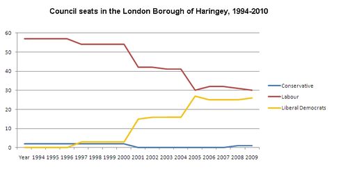
The borough has been Labour-run since 1971. No Conservative candidate has won a local government election in Haringey since 1998. In May 2006 Labour retained control of the Council with a majority of just three seats over the Liberal Democrats.
Late in 2007 Liberal Democrat councillors Catherine Harris and Ali Demirci crossed the floor to join the Labour Party, the first such occasion in the history of the borough. The Labour majority thus increased to 7 (32 Labour, 25 Liberal Democrat). In July 2009, councillor and former mayor Alan Dobbie left the Labour Party to join the Conservatives, becoming the first Conservative in the council for 11 years.[20]In January 2010, Brian Hayley became the first ever Haringey Labour councillor to defect to the Liberal Democrats.
Labour increased their majority to 11 at the May 2010 local elections, winning 34 seats to the Liberal Democrats' 23.
Seats on Haringey Council, by party:
| Year | Conservative | Labour | Liberal Democrats |
|---|---|---|---|
| 1994 | 2 | 57 | 0 |
| 1998 | 2 | 54 | 3 |
| 2002 | 0 | 42 | 15 |
| 2006 | 0 | 30 | 27 |
| 2007 | 0 | 32 | 25 |
| 2009 | 1 | 31 | 25 |
| 2010 | 1 | 30 | 26 |
| 2010* | 0 | 34 | 23 |
(Boundary changes in 2002 reduced the number of councillors by 2)
- after local elections in May
In recent years, Haringey Council has become the subject of nationwide criticism over its handling of the welfare of young children, in connection with the murder of Victoria Climbie and the death of Baby P.[4] George Meehan, Council leader at the time of both the Victoria Climbie inquiry and the death of Baby P, resigned after a "damning" examination of Social Services caused by Baby P. He and Liz Santry, cabinet member for Children's Services initially refused to resign at a Full Council meeting. All Labour Councillors voted for them to remain in their posts. Sharon Shoesmith, who was sacked on 8 December 2008 without any compensation package over the Baby P affair, is suing for lack of notice.
In March 2009, the council's overall performance was assessed in an Audit Commission review as among the fourth worst in the whole country, and the worst in London.[21] Its previous three stars were reduced to one.
Economy
In 2006, there were 8,200 businesses in Haringey employing a total of 64,700 people. This accounted for 1.6% of all employment in London.
Haringey's economy is dominated by small businesses with 94.2% of businesses employing less than 24 people. These small businesses account for 39.3% of total employment in the borough.
The main sectors of employment in Haringey are:
|
- Source[22]
The principal shopping areas in the borough are Wood Green and Turnpike Lane, Muswell Hill, Crouch End, and Harringay.
Haringey is situated within the growth corridor connecting London with Stansted, Cambridge and Peterborough.[17]
Culture
The borough has a number of facilities offering a wide range of cultural activity
Performing arts
Haringey's theatres include:
- Haringey Shed - an outreach theatre group of Chicken Shed Theatre.[23]
- Jacksons Lane.
- Mountview Conservatoire[24]
- North London Performing Arts Centre[25]
- In 2007, the new £14 million Bernie Grant Arts Centre[26] opened, as part of the borough's regeneration strategy.
- Downstairs at the King's Head[27]
- A wide range of small live music venues together with the bigger venues of Finsbury Park and Alexandra Palace.
Visual arts
- The Chocolate Factory[28]
Education
Haringey has 63 primary (including infant and junior) schools, 10 secondary schools, a City Academy, 4 special schools and a pupil support centre. In addition there is off site provision and study support centres for children and young people with additional needs. Ten Children’s Centres[29] were opened in 2006 and a further eight are planned for 2008.
The number of pupils in Haringey Schools as at January 2006 was 34,990 (Including nursery age children). This total was made up as follows:
- Primary Total 16,705 (pupils of compulsory school age).
- Secondary Total 12,431 (including sixth form students).
- Special School pupils and students 299 (including post 16 children).
- Pupil support centre 77.
- Source[16]
Sport
Tottenham Hotspur Football Club, currently in the FA Premier League, is located in the borough in Tottenham High Road.
London Skolars are a rugby league team that compete in National League 2, they play at New River Stadium in Wood Green, Haringey. The annual Middlesex 9s rugby league tournament also takes place at the New River Stadium.
The Borough's ice hockey team, the Haringey Greyhounds currently play at Alexandra Palace. Alexandra Palace has also hosted other events including the PDC World Darts Championship and a number of Boxing events.
- See also: Category: Sport in Haringey
Transport
London bus route 29, 41, 43, 67, 73, 76, 91, 102, 121, 123, 134, 141, 143, 144, 149, 184, 192, 210, 214, 217, 221, 230, 231, 232, 234, 243, 253, 254, 259, 263, 271, 279, 299, 318, 329, 341, 349, 444, 476, W3, W4, W5, W7, night route N20, N29, N41, N73, N76 and N91.
The numerous National Rail, London Overground and London Underground stations in the borough are:
- Alexandra Palace railway station
- Bowes Park railway station
- Bruce Grove railway station
- Harringay Green Lanes railway station
- Harringay railway station
- Highgate tube station
- Hornsey railway station
- Manor House tube station
- Northumberland Park railway station
- Seven Sisters station
- South Tottenham railway station
- Tottenham Hale station
- Turnpike Lane tube station
- White Hart Lane railway station
- Wood Green tube station
Twin towns
Haringey has been Town twinning with Koblenz, Germany since 1969.[30] It has also twinned with the towns of:
- Arima in Trinidad and Tobago,
- Clarendon in Jamaica,
- Holetown in St. James, Barbados,[31][32]
- Larnaca in Cyprus,
- Livry-Gargan in the suburbs of Paris, France,
- Sundbyberg in Sweden and
- Jalasjarvi in Finland
Notable current and former residents
There are a large number well-known people who have lived or are living in the borough, particularly in the areas of Highgate, Muswell Hill and Crouch End. The group includes Bill Nicholson, Ho Chi Minh, David Gray, Mike Leigh, Oliver Tambo, The Kinks, Chipmunk (rapper) and David Tennant from Doctor Who.
- See also: For comprehensive information on notable residents see: Category: People from Haringey by district.
References & notes
- ↑ Data Management and Analysis Group, Greater London Authority, Demography Update October 2007, (2007)
- ↑ It is interesting to note that pupils in local schools at the time the borough was created in 1965 were taught that the new borough's name should be pronounced with the ending sounded as in the endings of Finchley, Hackney or Hornsey - Valerie Crosby, Archivist, Bruce Castle Archives, London Borough of Haringey, 2007
- ↑ 3.0 3.1 London Borough of Haringey website, Facts & Figures
- ↑ 4.0 4.1 4.2 4.3 http://www.thisislondon.co.uk/standard/article-23590669-details/The+rotten+borough+of+Haringey/article.do
- ↑ 5.0 5.1 5.2 5.3 5.4 Office for National Statistics
- ↑ http://www.thisislondon.co.uk/standard/article-23657883-details/Borough+at+centre+of+Baby+P+row+ranked+the+worst+in+London/article.do
- ↑ London Evening Standard 9 December 2009
- ↑ 8.0 8.1 Madge, Stephen J. (1938). The Early Records of Harringay alias Hornsey. Public Libraries Committee Hornsey. ISBN : None issued at publication.
- ↑ T. F. T. Baker & C. R. Elrington (Editors) (1985). A History of the County of Middlesex, Volume 8: Islington and Stoke Newington Parishes. Accessed online at British History Online.
- ↑ T. F. T. Baker & R.B. Pugh (Editors) (1976). A History of the County of Middlesex, Volume 5: Hendon, Kingsbury, Great Stanmore, Little Stanmore, Edmonton Enfield, Monken Hadley, South Mimms, Tottenham. Accessed online at British History Online.
- ↑ Harringay is an area of London within the London Borough Haringey. The two differently spelt words describe different places and they are not interchangeable.
- ↑ London Borough of Haringey Website
- ↑ 13.0 13.1 London Borough of Haringey Website - Open Spaces Page
- ↑ The Natural History of Haringey, David Bevan
- ↑ English Heritage - Green Heritage Microsite
- ↑ 16.0 16.1 16.2 Knowing Our Children And Young People - Planning For Their Futures, Haringey Council, 2006
- ↑ 17.0 17.1 Audit Commission's Corporate Assessment of Haringey Council, October 2006
- ↑ London Borough of Haringey Website: Ethnic Group Theme Tables
- ↑ London Borough of Haringey Website Ward Profiles
- ↑ Pears, Elizabeth (8 July 2009). "Tories reclaim Haringey Council seat following shock defection by Labour councillor Alan Dobbie". Haringey Independent (Newsquest Media Group). http://www.haringeyindependent.co.uk/news/topstories/4480438.Tories_reclaim_Haringey_Council_seat_following_shock_defection/. Retrieved 8 July 2009.
- ↑ http://www.thisislondon.co.uk/standard/article-23657883-details/Borough+at+centre+of+Baby+P+row+ranked+the+worst+in+London/article.do
- ↑ Haringey's economic profile
- ↑ http://www.haringeyshed.org/
- ↑ http://www.mountview.ac.uk/general_information_level2.asp?level2_ID=65
- ↑ http://www.nlpac.co.uk/
- ↑ http://www.berniegrantcentre.co.uk/
- ↑ http://www.downstairsatthekingshead.com/
- ↑ http://www.chocolatefactoryartists.co.uk/
- ↑ Haringey Council Web page on Children's Centres
- ↑ Koblenz Tourism Website
- ↑ Twinning of London Borough of Haringey with Holetown: 10 December 2009PDF (13 KB) – Barbados Ministry of Foreign Affairs and Foreign Trade
- ↑ Twinning Of London Borough Of Haringey With Holetown
External links
- Haringey Council
- Key statistics on Haringey on London Councils website
- Key leadership information on Haringey Council on the London Councils website
- Alexandra Palace
- Harringay Online - independent website for Harringay Neighbourood, but used throughout the borough
- Haringey Greyhounds Ice Hockey Club
- Haringey London Borough Council - History
- Haringey Freecycle group
- Haringey Council Report, Knowing Our Children And Young People - Planning For Their Futures
|
||||||||||||||||||||
|
||||||||||||||